MARQUETTE, Mich. (WZMQ) – What’s being called the Saint Patrick’s Day Blizzard of 2026 is still hammering the Upper Peninsula at this hour
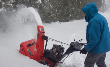
A powerful late-season blizzard is pounding communities across the U.P., bringing heavy snowfall, powerful winds, and dangerous travel conditions in cities across the region. Snow has been falling steadily as strong winds off Lake Superior create blowing and drifting snow, reducing visibility to near zero at times.
“Yeah, in terms of snowfall, it definitely is up there. At our office in Negaunee, we’re now up to the fourth snowiest winter today,” said Dan Thompson of The National Weather Service in Negaunee
Road crews have been working around the clock trying to keep major routes open. Authorities across the region are urging drivers to stay off the roads unless it’s absolutely necessary. Schools, businesses, and government offices have been forced to close as the storm continues to intensify.
“This one actually impacted probably the largest footprint of the U.P. in terms of events we’ve had this year, the only area it kind of spared, actually, was the Keweenaw Peninsula that didn’t see a whole lot of snow with this event,” explained Thompson.
The bottom line is that this St Patrick’s Day storm is sure to break records.
“This one is approaching a two-day record snowfall for our office in Negaunee. So through 2 pm today, we’ve had about 29 inches of snow so far with this event, and the two-day record is just under 32, so if we get about three more inches between now and midnight, this may be the most, the biggest two-day snowfall that we’ve had on record here,” said Thompson.