NEGAUNEE, Mich. (WZMQ) – Ahead of the very cold weekend, WZMQ 19 spoke with National Weather Service Marquette about where it all came from, and what to expect.
“We’ve had a bit of a disturbance in the weather pattern over the arctic,” explained Greg Sova, a meteorologist at NWS Marquette. “That has caused some air mass typically over Northern Canada to sink further south and reside more over the northern United States and southern Canada.
Through Friday and Saturday, sub-zero temperatures and dangerously cold windchills are dropping some Upper Peninsula communities to feel close to 50 below. Sova says it’s been about seven years since our winter weather patterns have been this severe.
“This current arctic air outbreak is not going to be quite as long-lived as the January 2019 event, but we will see similar cold temperatures and windchills to then,” he said.
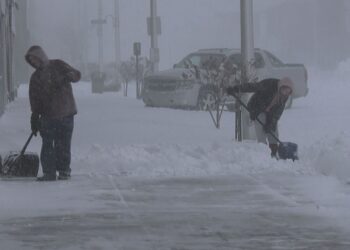
The conditions are easily capable of causing quick frostbite and dangerous travel conditions, due to the size of the precipitation and high wind gusts.
“When it is this cold, the snowflakes are very small and fine, which are very good at reducing visibility, especially with lake effect snow present,” said Sova.
Before leaving the house, make sure to double or even triple up those layers, while covering any exposed skin.
“Windchills in the negative 30’s can create frostbite in ten minutes,” said Sova. “Reducing any exposure to the outside air will help keep frostbite at bay.”
The below-normal temps are expected to last into next week, but will still remain serious for an extended period of time. To remain updated, visit WZMQ 19’s First Warning Weather Forecast, or the National Weather Service’s coverage at www.weather.gov.