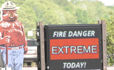
NEGAUNEE, Mich. (WZMQ) – There are several points throughout the year for wildfires to be on the rise. In the UP, due to the later snowfall and rapid warm-up, fire danger can be more of a concern. This time of year is usually the height of wildfires in the Upper Peninsula.
In 2012 the Duck Lake Fire took place in Luce County, burning over 20 thousand acres on May 23rd.
In July of 2021, 6 acres at the Pictured Rocks National Lakeshore burned in July of 2021.
Several campgrounds and trails in Houghton burned up 10 acres on Aug. 13 just last year.
These instances all had similar conditions to what we’re experiencing right now, with a more dry climate and lack of rainfall, which can bring the fire danger to an extreme level like it was on Tuesday.
“Things are pretty dry out there and we walk around if you haven’t been watering your grass or you go places where there’s not that much irrigation you can kind of see already a little bit of browning starting to occur out there,” commented Meteorologist Matt Zika.
National Weather Service notes that even though it may be warm, and drying up the grass, wildfire conditions can still be a gust of wind away.
“That’s the last critical ingredient we would need to be really really concerned so the fact that the winds have been light has helped us at least a little bit with regards to the overall fire danger,” continued Zika.
The humidity level is a more prominent factor as well. Even though there is lush greenery around during the summer months and later spring, the lack of moisture can make grass go dormant.
“If you have the combination of warm temperatures, temperatures in the 70s, 80s even the 90s if your winds are gusting,” Zika noted.
Zika noted that can be the perfect equation for a spark to grow into a wildfire. “Not everybody’s gonna see rain during that time but at least there’ll be small chances for a couple of showers. I wouldn’t anticipate widespread significant rains across the UP for at least another 10 days,” continued Zika.


