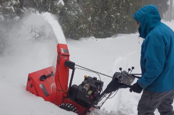
MARQUETTE, Mich (WZMQ) – On Thursday morning, the snow coverage blowing in caused school closings and continuing slippery road conditions in Marquette and the neighboring cities. The NWS Meteorologist Matt Zika said that when they’re forecasting these winters, they typically look at the Great Lakes, due to the massive size and the amount of wind coverage over the lakes. “When we forecast in the winter time, we’re often looking up here in the Great Lakes”, said Zika.
The 22-23 winter in the Upper Peninsula has been noted to be a bit more mild, however, Thursday morning seemed to spark a shift in the season with inches of snow continuing to fall. Meteorologist Karl Bohnak says the storm originated in the southeastern parts of Colorado. Bohnak spoke about the “Colorado Low” as a low-pressure area developing the storm. “These are the systems that bring all the wider spread upper peninsula snows”, said Bohnak.

Zika said they actually monitor the atmosphere more than the storm coverage on the ground. From 5,000 ft up in the air, observing the patterns of clouds and precipitation from the atmosphere. “When it comes to forecasting the weather when meteorologists are deciphering what’s gonna happen, we don’t start looking at what’s happening on the ground.”, continued Zika.
“It depends upon a number of things, the temperature of the atmosphere when your getting these snowflakes too”, said Bohnak.
The NWS says that he horizontal winds can create more airflow into the region, developing the storm like we’re seeing. WZMQ will keep you updated as the storm continues.


